Improving tide gauge estimates of sea level rate in earthquake-affected areas by nonlinear Vertical Land Motion modelling
In earthquake-affected areas such as the Western North Pacific, Alaska, Indonesia or South America, tectonic motion resulting from the collision of plates plays a main role in relative sea level (RSL) rise and represents the largest contributor to vertical land motion (VLM). VLM models for these areas should include at least a velocity change, occurring at the time of the earthquake. Models can no longer be considered as linear.
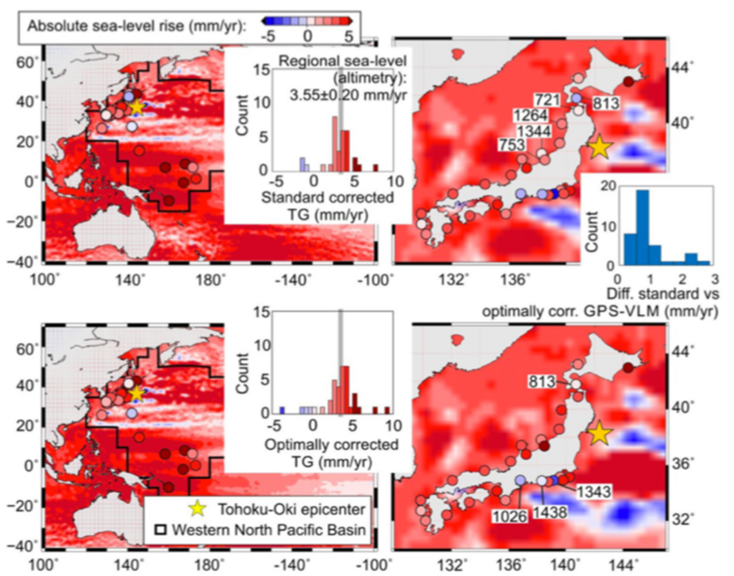
In a recently published paper Klos et al., 2019, a collaboration with colleagues from the Warsaw Military University of Technology, Poland, the IGG/Uni-Bonn, Germany and the University of Beira Interior, Portugal, we propose a new methodology that better represents the Global Positioning System (GPS)-derived nonlinear VLM and noticeably improves absolute tide gauge sea level (ASL) estimates by 20% on average, bridging their difference with altimetry estimates. Furthermore, employing the new nonlinear VLM model leads to a much better agreement between direct and indirect RSL estimates, which is of high importance for coastal engineering and planning.
Traditionally, tide gauge records are corrected for VLM using model-based Glacial Isostatic Adjustment (GIA) corrections, which however contain large uncertainties related to the insufficiently known viscoelastic properties of the earth’s interior; moreover this ignores any land motion caused by present-day tectonic, seismic and environmental effects. Thus, the key assumption of linear VLM over the entire time span of tide gauge records is not true, particularly for areas influenced by present-day time-varying (e.g. volcanic, human, tectonic) processes.
In the Western North Pacific for the 1993–2015 period, simply discarding all earthquake-affected sites, the average RSL rise is overestimated by more than 0.5 mm/year. Not accounting for the changes in vertical velocities and displacement due to the tectonic movements and estimating ASL rise from tide gauges can result in an error of 10 mm/year. Disregarding VLM would lead to misestimating local sea level trends between 0.2 and 7.6 mm/year. If accounted for, but modeled as linear during the entire time span, VLM leads to regional ASL rise errors of up to 0.4 mm/year.
The newly proposed nonlinear VLM model accounts for co-seismic offsets, changes in the vertical velocities and post-seismic transient, therefore allowing for a better usage of data from tide gauge stations in earthquake-affected areas, which would otherwise be normally excluded from the already poor spatial sampling network of tide gauges. We find a maximum difference of 15.3 mm/year between pre- and post-seismic vertical velocities. The GPS-sensed vertical co-seismic displacement approaches 36 mm. The improved nonlinear VLM model reduces the difference between altimetry- and tide gauge-derived ASL trend estimates as well as for the reconstructed by tide gauges Western N. Pacific sea level. The new VLM may also be helpful to estimate RSL rise for areas where tide gauges were destroyed during large earthquakes, as the S. America Pacific coasts, where only a few tide gauges are operating at the moment.
This innovative work is published at GPS Solutions: