Advances in high-performance elevation model computation and contributions of Arctic glaciers to sea level rise
Mountain glaciers and ice caps are retreating in most regions of the world. Within the SPP „Sea level rise and society“, the SATELLITE project initially estimated ice volume change and its contribution to sea level rise of almost all glaciers outside the polar regions during the first decade of the 21st century by means of satellite-borne synthetic aperture radar (SAR). Upcoming new measurements of recent years and the ongoing acceleration of glacier mass loss in many mountain regions require an efficient processing infrastructure. Also, mass changes of the vast glacierized regions of the Northern Hemisphere polar region, which have been balanced or close to Zero during past decades, are becoming increasingly negative. Those regions could have the potential to strongly contribute to global sea level rise due to their sheer size. New computing capacities are necessary to efficiently measure region-wide glacier elevation changes of the mid- latitudes mountain regions and extend the analysis to the large Arctic glaciers and ice caps.
The transfer of data processing to High Performance Computation Center NHR@FAU was an envisaged project goal of SATTELITE 2. Now it is close to completed thanks to the fruitful support of the NHR team: The resources for hundreds of Petabyte of satellite data imagery were obtained and integrated in the data supply chain. Code optimizations towards a multi-node parallel computation of the several thousand DEM scenes were implemented and tested. Taking the last steps towards an operationally programmed surface elevation change and mass balance computation module, we see promising results: Computation time is reduced by up to 80%. This facilitates reaching the ambitious goal of the second project phase: to shed a light on the global perspective of accelerated glacier mass change and the resulting contribution to sea level rise. Once fully available, the second global coverage of glaciers, acquired by the twin satellite TanDEM-X, will be assessed within weeks, instead of several months time. This will add a
profound knowledge on the role of glacier as increasing driver of sea level rise. The results of a regional survey carried out in the Russian Arctic in the meantime give a first impression of that.
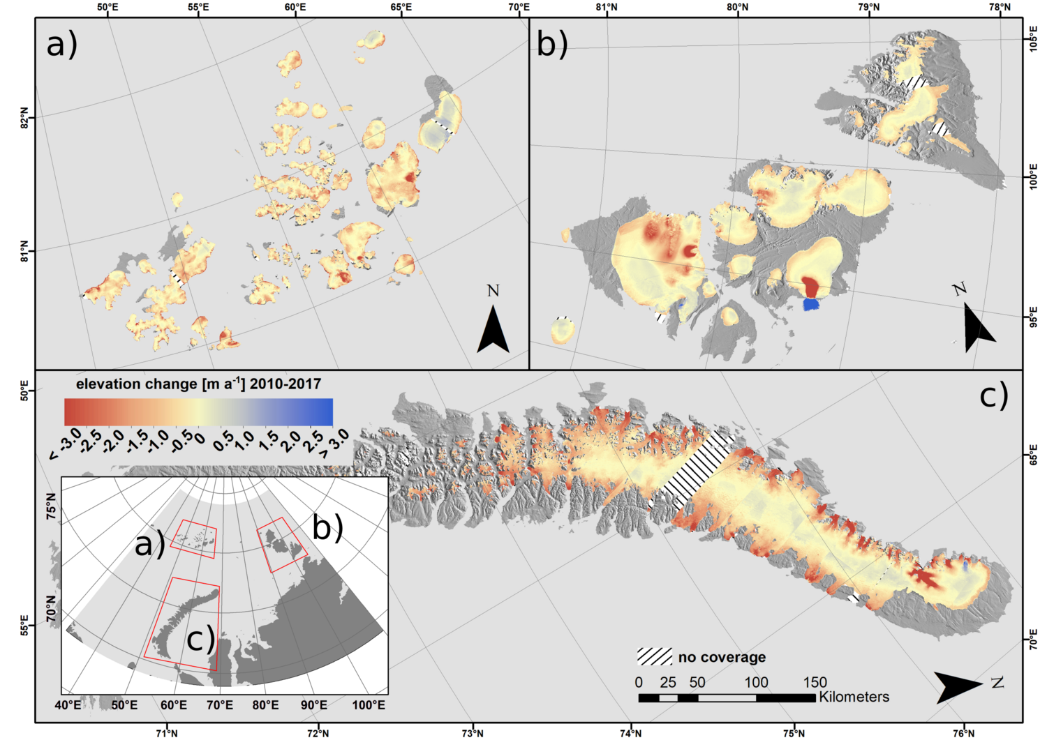
Within the 21st century, the Polar Regions have been subject to extensive warming due to global climate change. However, there are few broad- scale observations of Arctic glacier dynamics outside the Greenland ice sheet. A first analysis of glacier elevation change was conducted at the Russian Arctic archipelagos of Novaya Zemlya, Severnaya Zemlya and Franz Josef Land (~52,000 km2 glacier area). The results showed a high vertical accuracy of the interferometric X- Band SAR and revealed a mass loss of -23±5 Gt a-1, corresponding to a sea level rise contribution of 0.06±0.01 mm a-1 between 2010 and 2017 (Fig.3). Compared to measurements of past decades, glacier mass loss in this region has almost doubled in recent years. The respective publication is currently under review in the journal „The Cryosphere“. In future, the analysis will be extended to the remaining Arctic glaciers and ice caps outside the Greenland ice sheet (Alaska, Arctic Canada, Iceland, Svalbard and North Asia) to better constrain Arctic glacier mass change.
Publication: Sommer, C., Seehaus, T., Glazovsky, A., and Braun, M. H.: Brief communication: Accelerated glacier mass loss in the Russian Arctic (2010–2017), The Cryosphere Discuss. [preprint], doi.org/10.5194/tc- 2020-358, in review, 2020.